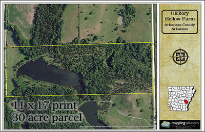
Custom Aerial Property Map
- Availability:
- Product usually ships in 1-3 days from your order date.
- Bulk Pricing:
- Buy in bulk and save

Custom Property Aerial Map
Aerial maps provide an eagle eye view of the earth and offer more than just a pretty picture from above. While many of our customers do purchase these maps as a proud display of land ownership for their home and office, these maps are also a valuable resource.
These type of maps are also extremely useful in planning development or landscaping, better understanding the relationship of land with surrounding properties, or as an amenity to those using your land.
Upon receipt of your order, our cartographers will access and confirm the latest available property lines. Positioning them against a backdrop of aerial imagery, the final product is printed on high quality gloss cardstock, suitable for framing.
Included on your map:
-
Aerial Imagery, typically obtained from the United States Department of Agriculture Aerial Photography Field Office National Agriculture Imagery Program
-
Property Boundaries, typically obtained from your local County Assessor Office.
-
Prefer not to include property lines, tell us in the special instructions!
-
Map Title you provide
-
County and State of the property
-
Scale (Bar, Ratio, and Representative Fraction)
-
Full Color Print on Premium 100# Gloss Cover Stock
Note: The maximum scale available for these maps is 1:3600, or 1 inch = 300 ft. Imagery can still seem just slightly out of focus at this scale. Samples of a ½ acre tract, 1-acre, and 5-acres at this scale are shown above. The images shown above are just samples showing how the layout of the map will appear, your property and map title will be shown on the final map.
If you need a larger or smaller print size, or are interested in displaying more location features on your map, get in touch with us. We can customize any map to fit your need.
Need Additional Map Prints? - Purchase 2 or more maps and receive 25% off.
Note: Maps will ship 1-3 business days from order date. If map is laminated, allow 3-5 days to ship. Any order specified overnight delivery will ship UPS Next Day Air once the map is complete. Maps containing historical imagery may take up to 2-3 weeks depending on the area. Once we receive your order, our cartographer will contact you with the available options, a timeline for completion and a digital proof by email.
Read more about all of our custom map options.
6 Reviews Hide Reviews Show Reviews
-
Property + Topo Map exceeded expectations
Very pleased with timing, interaction, and quality of a custom map which included parcel outline and topo lines. Using as a wall map to mark trails.
-
Custom aerial map
Ordered an aerial map of our farm with a historical image beside to compare. Finished product is fantastic. Not enough good words to say about the customer service from Jennifer. So awesome to receive such great service in today’s market!
-
Fantastic Service. Wonderful Product. Super Gift
The Mapping Solutions team were incredible to work with - fast reply, easy and user-friendly proof review process, and great communicators. The maps are fantastic, and better than expected. I gave this as a gift and my brother was really delighted. Thank you Mapping Solutions team!!
-
Awesome gift
My husband loved this as my first anniversary gift to him.. I was even able to add a cute little note to look back on in 50 years! Thanks so much!
-
Very pleased
Received it yesterday via USPS and my husband was very pleased.
-
Custom Aerial Map is Great!
Got this for my parents, and it is going to look great up on the wall!


